26 June 2005

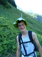
Testing my limits. A flight in Orcier.

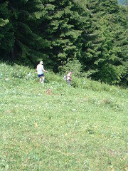
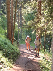
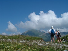
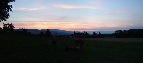
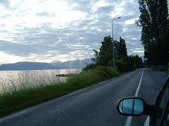
After a good lunch and a nice siesta, we all pile-up in various vehicles (the truck comes to the fore in this occasion) and drive to Très-le-Mont. The wind has shifted from the East a little, and we transfer to Le Couteau which is more appropriate for North-Easterly winds. When we get there, a few people are finalising their preparation and there's even a hang-glider getting ready to launch.
View from the top.
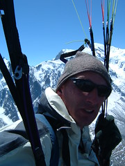
The wind is shifting capriciously, the take-off is not very sound anymore, with the thermals triggering just in front of the frop-off. We watch a few pilots take off, and the antics they unvoluntarily perform are proof that it is necessary to be cautious during this delicate phase of the flight. I let a few more pilots take off before I lay my wing and check my risers. Finaly, I'm in the slope and I wait for the right gust of wind. My perception of the airflow is not hindered by my helmet, as I forgot it at the landing terrain, I'm thus wearing the spare, transparent one to comply with the local rule that all pilots have to wear a helmet...
A few more minutes wait, and I'm pulling the wing up behind me, I chose a weak gust and it's climbing slowly, I'm going to compensate by running fast. One quick look up to verify that none of the risers are tangled and that the wing looks fine, and I'm pushing in the harness to get a correct speed.Look who's behind... 
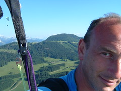
The wing is fairly stable; as expected it tends to turn right, to match the incoming wind direction. I correct it very little and in a few seconds it carries me. As I try to sit into the harness, I discover I'm stuck. I decide to stay hanging until I'm in a stable flying situation. It only takes a few seconds to get everything going smoothly. I've picked up a nice ascendence on the right of the take-off and I'm at a safer height, I wriggle in the harness and flip back while raising my legs, and manage to sit in a comfortable position after a few contorsions. Hide and seek 
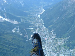
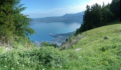
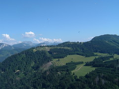
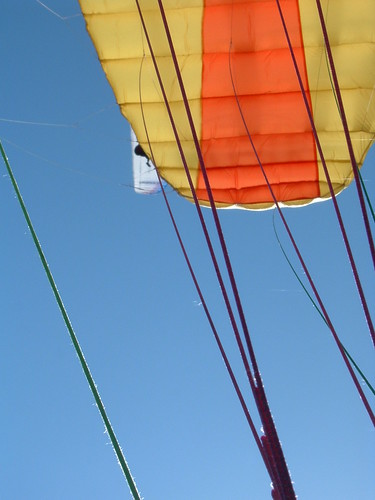
The problem comes from the radio in my pants pocket, it's pressing hard on my thigh, and that's what made the whole task so difficult. I make a note not to use my pants pocket for anything while I struggle to pull the camera out of the other pant pocket. For the rest of the flight, it will stay in my lap, but for now, I have my hands full controling this flight. The thermals are quite big, a lot of the pilots gain altitude quickly, and I manage to join the crowd at the front of the crest above Orcier. It's a rollercoaster ride as I traverse the thermals and get bumped upwards. After a long while, things quieten down, and I look around, there are much fewer paragliders around, I scan the horizon and can't see any of them in the distance. I haven't been paying much attention, but it looks as if many of them have landed. There's been a steady flow of pilots taking off from Le Couteau, Olivier and Michael have done a few teandem flights, and waved as they were coming past. Icarus... 
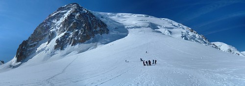
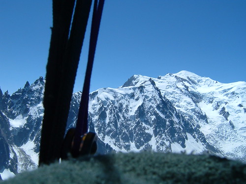
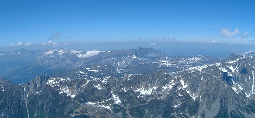
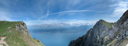
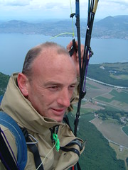
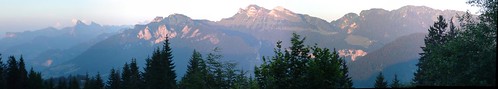
I check my instrument, and an't believe my eyes: I have been in the air for just over two hours! I briefly consider going in to land, but then the Mont-Blanc catches my eye and I decide to gain yet more altitude to snap a few pictures. It's a battle, as the sun has dropped on the horizon, it's almost 19:00 and the shadows are lengthening, giving us gentler thermal activity. The wind from the East is still making itself felt strongly at altitude, though. After getting the snaps I wanted, I realise I'll have to land soon. I'm getting a headache I think is due to dehydration, the Blanc-Cassis Francis poured generously at apéro time is not helping, and I decide it's not really worth pushing the experiment further: I now know I can concentrate on the flying for an extended period of time. I reach the landing with a lot of altitude to spare, and take this opportunity to do a nice approach, spending the altitude upwind of the terrain. It's a good thing my final approach and touchdown are very smooth, as it feels like two rubber stump have replaced my legs when I try to stand. Before I switch it off, I check my vario, and it tells me I was in the air for three hours and fifteen minutes. I think this will stay my record for a while...
pano - Dent d'oche a Niflon
Technical data: Flight duration 3:15, Take-off altitude: 1355m, Maximum altitude reached: 1675m, Total climb during flight: 6030m, Max rate of climb: +3.8m/s, Max descent rate: -4.6m/s, Landing altitude: 640m.

Yearly cleanup at the CHOTO.

Every year, shortly after the beginning of the flying season, we go and cleanup the take off spots. Our club is fairly unique, in that it actually owns the main take-off spots we use, and we rent the landing field, thereby ensuring a safe, controlled environment we can suit to our needs. With ownership comes the duty of care, and every year we meet to cut the bush that inevitably tries to grow in the steep slopes of our playgound. Cleaning up So it is that on this Sunday morning, three dozen men and women meet to drive to the take off spots. This is the only time in the year where we use 4x4s to drive all the way to the end points of the paths, having the excuse of the tools and other accessories to cart there. We thus spend the morning clearing tall grass, raspberry and blackberry bushes, ferns and other mountain plants.
As lunchtime approaches, the job is finished, and we are all keen to go back to the cars to fetch our wings and try the newly cleaned take-off strips. We don't expect much in terms of flying performance, it's too early in the day for thermals to have built up steady streams on the slopes and the flight will be a short one. Nevertheless, it's more fun to arrive at the party table flying than in a car, ands our cooks have done well, as usual, to satisfy the workers.

Technical data: Flight duration 0:13, Take-off altitude: 1350m, Maximum altitude reached: 1350m, Total climb during flight: 118m, Max rate of climb: +1.6m/s, Max descent rate: -4m/s, Landing altitude: 640m.

19 June 2005

Week-end stroll - La Bombardellaz

It's Sunday, and on Sundays, we have to go to church. The only exception, of course, is for those who go mountaineering and paragliding, so to keep the exemption valid, I decide to join my friend Dédé and his family for a gentle outing. Montee vers les Aravis 1 The planned destination of the walk is "La Bombardellaz", a chalet that was used for summer grazing in the years gone past. One of Dédé's great aunts used to guard a flock of sheep in the steepest "combe" of the Aravis range. Arnica
We leave the car in the parking at the end of the road. The altitude is about 1000m (!!! To be confirmed !!!). As is common in our region, the path is very steep at the start, had the terrain been less steep, the road would have been extended and the parking situated higher, to allow lazy buggers to drive further.
We climb a few hundred meters altitude in the forest, and enjoy the cool air in the shade. The meteorological office has repeatedly warned everybody about the high temperatures to be expected this week-end and we're glad to have left the scorching heat in the valley.
Lys Saint Bruno
After less than an hour climb, we exit the forest and have a chance to admire the Aravis range. We scramble accross a steep furrow dug by a small stream. We stop several times to observe some rare flowers in the lush grass, it's very nice to travel with knowledgeable people. After another short steep climb, we reach the almost level main path that runs from Les Confins to Le Col des Annes. We'll shortly be to our destination.Improvised hat
After a gastronomic stop to enjoy our sandwiches, it's now time for me to lay out my wing. I've been observing the wind during our lunch break, and there is very little activity on the hill where we are. On top of the range, it's another story, as the clouds are moving fast and in a very turbulent manner. I suspect that I'll encounter quite a bit of wind in the valley. Contemplating...

My plan is to manage to cross the valley and keep enough height to catch a thermal on the sunny side and climb on the slope opposite us. Plan B is to simply land on the edge of the golf course situated about a kilometer down at the bottom of the valley.
I check my wing one last time and pull the risers. A few steps forward and I can feel it's above my head. One quick look, and I accelerate to take off. Another clean one.
From there, things go very fast. I only have 600m altitude above the bottom of the valley, and I don't have time to take my camera out. I look down and signal to Dédé that the path they intend to take to get down is indeed where we assumed it would be. That message somehow gets a little bit lost. I overfly the little village at the bottom of the valley. My target is the patch of clear rockface opposite us, and it looks like I'm just going to make it. As I get closer, I can see the trees under the patch of rock shake violently, the thermal is quite strong, and probably helped by the stong valley wind coming around the corner. I turn sligtly to align my trajectory parallel to the side of the valley, and I can feel my right wing get lifted, but the thermal is too violent and I get pushed to the left. I quickly do a full turn to give it another try, but the same thing happens, and I don't have enough height to give it another try safely, so I head for the middle of the valley to swing plan B into action.
After a few figures in a "S" shape, I line up for touchdown a meter before the edge of the first green, and drop my glider at my feet. There is inviting shade with clean ground to fold my wing and I don't have far to travel to find a shady spot suitable for a siesta while I wait for the pedestrians. Another enjoyable flight, although very short., and it's still early enough in the day to have another flight in Orcier later...
Technical data: Flight duration 0:08, Take-off altitude: 1567m, Maximum altitude reached: 1591m, Total climb during flight: 58m, Max rate of climb: +0.8m/s, Max descent rate: -4.8m/s, Landing altitude: 1000m.

18 June 2005

panoramic - Petetoz


panoramic - Petetoz
Originally uploaded by ParaScubaSailor.
No flight today, just a nice short walk with my friend Roger. Does that still count in this blog? Wait... _I_ make the rules here, so it counts. There...

17 June 2005

After Work - Sur Cou

Taking advantage of the longest days in the year, we meet after work to climb "Sur Cou", a mountain above "La Roche Sur Foron" that we climbed almost a year ago with
Maurice and his wife. On the occation of that outing, we discovered a very nice restaurant in Saint Sixt we planned on visiting again. We meet at our intended landing spot, and leave one car there. There is a nice long field where the grass was cut fairly recently, so we won't upset the local farmer.
Today so far has been a fairly nice day, with little wind, but there is a big cloud on top of our intended destination. It's situated higher and to the back of the top, so we suspect that a bit of Northerly wind is blowing in altitude.
On the way through the village, we stop in front of the restaurant to ask for directions, and book a table at the same time.
Sur Cou
We leave the car just after 19:00. The climb is very pleasant, through the forest. There are a few paragliders in the air already, and they seem to be holding their altitude, excitment is rising amongst the climbing troops.
It's a short climb, and we get to the top with plenty of daylight left for the flight. The cloud has moved forward though, and it's just above our heads. By the time we set our wings, the bootom of the clouds has dropped around us, and we can just see the fields at the foot of the hill through a mist. Alex and Fabienne take off first with the tandem wing, and they disappear immediately in the cloud. I wait a few seconds to give them time to clear the front of the take off area, wait for a slight gust and bring my wing above my head. Nice clean take off. I head straight out from the mountain face, and look for Alex in front of me. After a few minutes, I see him, slightly below me. He's pulled his ears in, my vario is beeping steadily, I pull my ears in, to clear the cloud. No point in flying blind, although this cloud is very quiet, with a neat limit and no sign of turbulence. A few more minutes and we're clear of the cloud. I look around for Maurice, but can't locate him. I worry a
little as I can't see the top of the mountain, where we took off, and I didn't see him get airborne. I finaly see him far on the right, much higher than we are. He looks like he wants to cross the Arve valley...
The airlow is fairly laminar, and with the slope of the terrain, we keep to the same altitude for a long time, and we have the time to enjoy the vista. I go over Orange and gain a little bit of altitude, but as I suspected, there's a fairly strong airflow. I play around in that area and then decide to go over to the other side.
As the sun nears the horizon, we get closer to the ground and it's time ot prepare for landing. The airflow is a bit more turbulent, with gusts probably kicked up by the terrain, trees and other obstacles.
sunset over St Sixt
We land as the sun sets behind the Jura. Folding the wings is routine, and we're quickly in the car to go back to the restaurant, where the waiter and her sister the cook are kind enough to feed us, hungry beasts.Après l'effort, le réconfort!
Overall, a very good evening was had by all, preparing a good week-end.

Technical data: Flight duration 0:44, Take-off altitude: 1726m, Maximum altitude reached: 1750m, Total climb during flight: 304m, Max rate of climb: +1.6m/s, Max descent rate: -2.8m/s, Landing altitude: 640m.

11 June 2005

Le Mont-Blanc du Tacul

This time, Michael has chosen an outing a little more daring than the usual ones, we have to take along crampons and ice picks. EquipmentThere are only four of us meeting on this fine morning. The weather forecast leaves a little bit of doubt, but we reckon we have fair chances of flying. It's a fair drive to Chamonix, capital of climbing and mountain sports, and Alex takes advantage to catch-up on some sleep. As we arrive in Chamonix, there are already lots of people waiting in line to get to the cable car and we buy our tickets to join them in the queue. Cable-car ticket There is a big display of brand new and shiny equipment. We spot a group of paragliders not far ahead.
We don't have much to wait, the cars go up every twenty minutes, and we joined the line early enough. In the cable-car, we briefly switch our varios on, and we record speeds up to 8m/s.
We arrive at the first station, and get into the second cable car. The air feels colder already. As we arrive at the second cable car station and step onto the bridge leading to the tunnel, the wind hits us. It's going to be a cold climb, and we worry about being able to fly at all. Maybe the return tickets weren't such a bad deal after all...
While still at the cable car station, we take advantage of the best invention civilisation has produced and go to the public toilet. The single flight of stairs to get there hit me. What's the matter with me? I feel drunk, my head is spinning, I'm afraid I might throw up any minute. The ascent in the cable car was too fast, and I'm not used to this altitude.I join the others and we quickly put our crampons on our feet inside the tunnel. As we exit the tunnel, the gorgeous vista is breathtaking. This was well worth it.
There is a well thread path on the ridge that almost everybody has to take to get to the departure point, on the pass at the foot of "L'aiguille du Midi", the only two people that don't join the troup on the path are busy fitting their skis on.
So far, so good. We follow the path on the glacier, on the right is the "Refuge des Cosmiques", well known and highly frequented as it's only an hour or so from the terminal of the cable car.
We get to the foot of the first serious climb and tie ourselves up with the rope Michael brought with him. panoramic - TaculWe start with a slow, steady rythm, but I can feel the altitude is taking its toll on my performance. I have to concentrate on keeping my balance, as I've lost all sensation of direction. If I move my head up too fast to look at the sky, I fall backwards. This climb is going to be hard.
Thankfully, it's fairly short, as we only have 700m to ascend. DSCF0177
The weather is great, limpid blue skies, and we are in the lee of the mountain, so we don't feel any wind. The air is cold, probably between minus five and minus ten. We mark a few seconds pause at every change of direction on the slope, to step over the rope and glance at the surrounding vista. We've been admiring this group of mountains from a distance and it's great to see all the places we've been to all around us, stretching to the horizon.
As we near the top of the ridge, Michael switches the radio on. We get the wind conditions from stations hundreds of kilometers away. The ones close to us are all saying the wind is coming up and we've just crossed path with a group climbing down, that were carrying paragliding bags on their backs. This is not very good news.
We march on and finaly get to the top of the ridge. The cold wind hits us in the face. Ouch! panoramic - Mont Maudit The view is beautiful, with "Le Maudit" just ahead. We confer a short while and decide not to climb any higher: the wind will only be stronger higher up. We look for a place oriented into the wind with enough space to lay the wings. I'll be first, Michael and Olivia will take off next, and Alex will close the flight. I'm concentrating hard as I know I'm far from my normal state. The wind is very gusty, thrashing my wing a few times on the ground. Alex and Michael both help me to hold the wing in position on the ground. In a lull, I attempt to take off, but the air is too thin and I'm too exhausted to run fast enough in the snow to inflate my wing properly. We lay the canvas on the gound again. I'm going to wait for the right gust: not too strong that it tears the wing away out of control, but stong enough to inflate it positively. I take advantage of the wait to breathe deeply and drink in as much oxygen I can. Finaly, "my" gust starts, I can feel the air on my face. I time it and pull on the risers. I feel the wing coming up behind me, it's on top at last. I glance up very quickly while running downhill as fast as I can, lifting my feet awkwardly out of the snow. As the slope steepens I feel the wing lifting, we're airborne! The gust lifts me violently up, I gain about fifty meters in a few seconds. The plan is to move away from the face of the mountain as fast as possible, as I'm in a zone of rotors. The headwind is very strong, my progress over ground is very slow. I'm about a hundred meters away from "L'aiguille du Midi" and I see the crowd on the bridge. They cheer and I wave at them. I've taken my camera out, but as I switch it on, it shuts down immediately. The batteries can't take the cold. I'm now flying in laminar airflow and consider removing the batteries from the camera case to warm them in my mouth. I've already removed one glove, but I decide instead to put the whole camera under my shirt, I can't take the risk of loosing one battery.
This plan works: a few minutes later, the camera accepts to switch on, Mont BlancI turn off the LCD screen to save a bit of energy and manage to snap a few shots before I have to grab the controls to penetrate the inversion layer. In Flight - Mont BlancAs I fly lower, the air warms up, and I take in the vista of the valleys surrounding us. Straight ahead is "Le Désert de Platé" , panoramic - Desert de Platewhere we flew two week-ends ago. What a change in such a short time! The snow has almost disappeared. I look below me, and see a few gliders that have taken off at the first cable-car station, "Le Plan de l'Aiguille". They look very small. I look at their flight, so I can match my approach to theirs. It's the first time I land in Chamonix, and the description of the landing area Michael gave us gains by being complemented by direct observation of the local's manoeuvers.
After I'm confident that I'll get down safely, I go back to enjoying this flight, I'm still very high, probably 2000m above ground, making little headway into the wind. I move back to the side of the valley, expecting slower winds there, and I manage to go all the way to the Mont-Blanc tunnel entrance. Chamonix I turn around and immediately rush over the town. As I near the landing area, I can feel a lift area and take a few turns to regain some altitude.As I glance down, I see a few pilots doing their approach, the trees are shaking hard, the vally wind is pretty violent. I decide to end the flight before the conditions get much worse. A few S patterns bring me to the vertical of the landing terrain, and as I expected, the gradient in the last few meters accelerate me forward, a final resource brings me to a gentle stop, concluding a magnificent flight.
As I fold my wing, I see one, and then a second, wing high above l'aiguille du Midi. It's a relief to know that both Alex and Michael were able to take off.

Technical data: Flight duration 1:04, Take-off altitude: 4076m, Maximum altitude reached: 4100m, Total climb during flight: 615m, Max rate of climb: +3.8m/s, Max descent rate: -4.4m/s, Landing altitude: 1040m.

05 June 2005

Sunday outing - Le Grammont

Michael planned on an early start this morning: we have quite a bit of driving to get to Les Evouettes, a small village in the Rhone Valley, just at the beginning of the Lake of Geneva. We all meet at 6:00 at the landing field in Orcier, to wait for the inevitable late participant. While waiting we wonder about the thick cloud barrier, which edge is lit by the rays of the rising sun.
pano - Orcier - Sunrise on clouds edge
We get going and as we near the border, on the Eastern side of the "Lac Leman", we are treated to more displays of sun rays.
Sunrays
We start the ascent at a fast pace, our bags having gone up last night in Alex's 4x4. We'll get them back when we get to the lake of Tenay, where he spent the night. We leave the national road and after crossing slopes planted with grapes used to make well known white wine in this region, we're soon in the forest. It's cool and pleasant and the walking rythm is kept brisk. We have quite a climb today, 1600m as we started from the lake level (400m altitude) and we're going to the top of Le Grammont, culminating at about 2000m.

We soon reach a clearing in the forest where we get a beautiful view of the end of the lake, where the Rhone river enters it. panoramic - Lac Leman - Vevey-Montreux Montreux (of the Jazz festival fame) and Vevey are visible on the shore opposite us.

We reach Tenzy in about two hours, and meet Alex and Fabienne. We have time to eat a few chocolate snacks nd drink some water, and we're off again. The signs here say it's a two hours climb to the top of the Grammont, a little over an hour later we're on the pass just below the summit.
panoramic - Lac Leman depuis le Grammont
The scenery is magnificent from here, with a front view of the Eastern side of the lake. Another twenty minutes on the final ridge and we're at the top. We relax and chat for a bit, and it's time to prepare for the take off.
Alex, Michael and Olivier will leave first, as they're all piloting tandem wings with passengers.
They take off and swoop in front of the take off, taking advantage of the dynamic lift to stay at the same level for a bit.
Time now for us to prepare for the take off. Maurice is first to go, then, after a few minutes, Philippe follows him. I take a bit longer as with all this waiting, my wing has bunched-up and I have to lay it properly again. At last I'm ready, a gust of wind feels just right, and I make a well controled take off, impressing the numerous climbers on this popular outing.
In flight
I do a couple of passes in front of the take off area, but the wind has dropped a bit, and I don't gain any altitude, so I decide to fly to the North side of the mountain to start on the flight to the valley.
This is a magnificent flight, where the view on the Rhone valley is unrivalled.
LAnding is a close one, as the wind blowing up the valley is very strong, and I let myself get blown away a tad too much. My progress upwind is very slow, but I manage to reach the landing field where I see my friends packing their wings on the ground. It's again an almost standing still touchdown, concluding a magestic flight.

Technical data: Flight duration 0:20, Take-off altitude: 2172m, Maximum altitude reached: 2172m, Total climb during flight: 100m, Max rate of climb: +1.8m/s, Max descent rate: -3.2m/s, Landing altitude: 385m.