Flying in Corsica
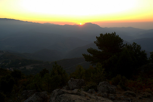
This is the first day I'm on my own in the island. I get up early, as the day light starts lightening the darkness of the night on the edge of the horizon, and walk from Poggio di Venaco to Riventosa and then to Santu Pietru di Venaco, where the path starts to the Bergeries de Taratalla. I want to get to the limit of the trees to see the rising sun. The show is magnificent, with the sun rising red through the morning fog.
I resume the ascent and get to the intended take off point at seven thirty. I can feel some puffs of wind already, but nothing worrying, they're extremely gentle. After a quick bite to eat, I lay my wing carefully. I'm alone, nobody knowledgeable around, nobody knows exactly where I am, so there's no latitude for errors.
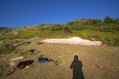
My take off must work the first time without hesitation.I follow each riser from the harness to the wing one at a time, making sure they're free of knots and tangles. There's no rush, I reckon I have an hour's window before the wind starts any significantly, so I really spend time on double checking everything. After a couple of panoramic photographs, I put the harness on, have a last look around and pull on the front risers. I can feel the wing rising evenly behind my shoulders. I step forward at a measure speed to give myself time to look up and do a quick check. All fine. Another two steps while accelarating and I'm airborne. I'm surprised to feel a tiny bit of turbulence. The sun has been up for less than an hour, less than half an hour at the bottom of the valley, and there's already measurable movement...The calculations I made on the back of an envelope show that I have enough height to reach Poggio, but I don't take any chance on this first flight and head straight for my destination.
The view is magnificent. I can still see the shining reflection of the sun on the sea, and the morning fog in the surrounding valleys. As I pass the crest on the left-hand side, Corte becomes visible. It's beautiful with the mountains profiled behind the town.
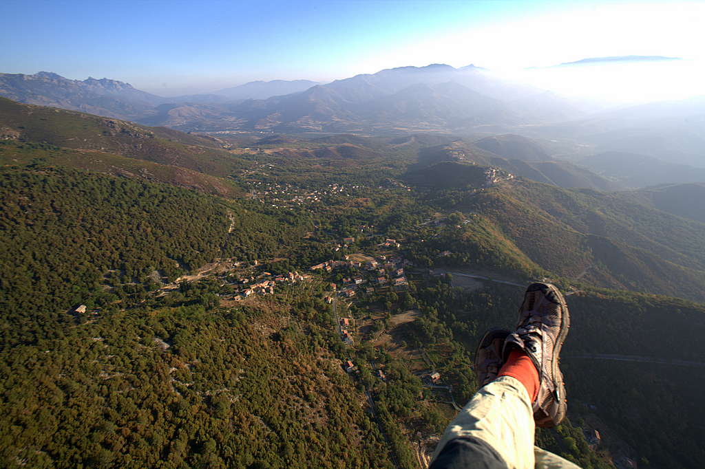
I look down and see cars circulating on the national road. Probably people going to work. There's little movement yet in the villages.
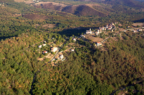
As I pass the top of the valley below Riventosa, I feel a slight turbulence. The sun activity triggers the air mass very early...I have quite a bit of spare height, as I wanted, and I do a couple of turns in front of Annette's house, but the people on the balcony haven't seen me and get back inside the house.I have enough time for another turn, and head for the other side of the village, where I spotted a field that I think suitable for my landing. I line up, but I'm still too high. I do a small turn to lose the extra height and come in just fine. At the last minute, I realise there's a slight wind from my right hand side, pushing me to the top of the field. I'm not worried, as I have a bit of spare distance there, but as soon as my feet touch the ground, my wing deflates and collapses on my left, on top of an olive tree and a spiky bush. Great! An hour and a half climb, ten minutes flight and twenty minutes to get my glider back...
Nevertheless, the scenery was awesome, and the feeling great!
Time to go for breakfast...
Technical data: Flight duration 0:33, Take-off altitude: 1344m, Maximum altitude reached: 1344m, Total climb during flight: 33m, Max rate of climb: +0.6m/s, Max descent rate: -2.8m/s, Landing altitude: 640m.
I resume the ascent and get to the intended take off point at seven thirty. I can feel some puffs of wind already, but nothing worrying, they're extremely gentle. After a quick bite to eat, I lay my wing carefully. I'm alone, nobody knowledgeable around, nobody knows exactly where I am, so there's no latitude for errors.
My take off must work the first time without hesitation.I follow each riser from the harness to the wing one at a time, making sure they're free of knots and tangles. There's no rush, I reckon I have an hour's window before the wind starts any significantly, so I really spend time on double checking everything. After a couple of panoramic photographs, I put the harness on, have a last look around and pull on the front risers. I can feel the wing rising evenly behind my shoulders. I step forward at a measure speed to give myself time to look up and do a quick check. All fine. Another two steps while accelarating and I'm airborne. I'm surprised to feel a tiny bit of turbulence. The sun has been up for less than an hour, less than half an hour at the bottom of the valley, and there's already measurable movement...The calculations I made on the back of an envelope show that I have enough height to reach Poggio, but I don't take any chance on this first flight and head straight for my destination.
The view is magnificent. I can still see the shining reflection of the sun on the sea, and the morning fog in the surrounding valleys. As I pass the crest on the left-hand side, Corte becomes visible. It's beautiful with the mountains profiled behind the town.
I look down and see cars circulating on the national road. Probably people going to work. There's little movement yet in the villages.
As I pass the top of the valley below Riventosa, I feel a slight turbulence. The sun activity triggers the air mass very early...I have quite a bit of spare height, as I wanted, and I do a couple of turns in front of Annette's house, but the people on the balcony haven't seen me and get back inside the house.I have enough time for another turn, and head for the other side of the village, where I spotted a field that I think suitable for my landing. I line up, but I'm still too high. I do a small turn to lose the extra height and come in just fine. At the last minute, I realise there's a slight wind from my right hand side, pushing me to the top of the field. I'm not worried, as I have a bit of spare distance there, but as soon as my feet touch the ground, my wing deflates and collapses on my left, on top of an olive tree and a spiky bush. Great! An hour and a half climb, ten minutes flight and twenty minutes to get my glider back...
Nevertheless, the scenery was awesome, and the feeling great!
Time to go for breakfast...
Technical data: Flight duration 0:33, Take-off altitude: 1344m, Maximum altitude reached: 1344m, Total climb during flight: 33m, Max rate of climb: +0.6m/s, Max descent rate: -2.8m/s, Landing altitude: 640m.
Labels: paragliding, parapente
posted by ParaScubaSailor at 21:37
1 comments
![]()
![]()
