Week-end stroll - La Bombardellaz
It's Sunday, and on Sundays, we have to go to church. The only exception, of course, is for those who go mountaineering and paragliding, so to keep the exemption valid, I decide to join my friend Dédé and his family for a gentle outing. 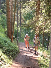 The planned destination of the walk is "La Bombardellaz", a chalet that was used for summer grazing in the years gone past. One of Dédé's great aunts used to guard a flock of sheep in the steepest "combe" of the Aravis range.
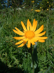
We leave the car in the parking at the end of the road. The altitude is about 1000m (!!! To be confirmed !!!). As is common in our region, the path is very steep at the start, had the terrain been less steep, the road would have been extended and the parking situated higher, to allow lazy buggers to drive further.
We climb a few hundred meters altitude in the forest, and enjoy the cool air in the shade. The meteorological office has repeatedly warned everybody about the high temperatures to be expected this week-end and we're glad to have left the scorching heat in the valley.
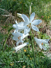
After less than an hour climb, we exit the forest and have a chance to admire the Aravis range. We scramble accross a steep furrow dug by a small stream. We stop several times to observe some rare flowers in the lush grass, it's very nice to travel with knowledgeable people. After another short steep climb, we reach the almost level main path that runs from Les Confins to Le Col des Annes. We'll shortly be to our destination.
After a gastronomic stop to enjoy our sandwiches, it's now time for me to lay out my wing. I've been observing the wind during our lunch break, and there is very little activity on the hill where we are. On top of the range, it's another story, as the clouds are moving fast and in a very turbulent manner. I suspect that I'll encounter quite a bit of wind in the valley.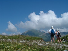
My plan is to manage to cross the valley and keep enough height to catch a thermal on the sunny side and climb on the slope opposite us. Plan B is to simply land on the edge of the golf course situated about a kilometer down at the bottom of the valley.
I check my wing one last time and pull the risers. A few steps forward and I can feel it's above my head. One quick look, and I accelerate to take off. Another clean one.
From there, things go very fast. I only have 600m altitude above the bottom of the valley, and I don't have time to take my camera out. I look down and signal to Dédé that the path they intend to take to get down is indeed where we assumed it would be. That message somehow gets a little bit lost. I overfly the little village at the bottom of the valley. My target is the patch of clear rockface opposite us, and it looks like I'm just going to make it. As I get closer, I can see the trees under the patch of rock shake violently, the thermal is quite strong, and probably helped by the stong valley wind coming around the corner. I turn sligtly to align my trajectory parallel to the side of the valley, and I can feel my right wing get lifted, but the thermal is too violent and I get pushed to the left. I quickly do a full turn to give it another try, but the same thing happens, and I don't have enough height to give it another try safely, so I head for the middle of the valley to swing plan B into action.
After a few figures in a "S" shape, I line up for touchdown a meter before the edge of the first green, and drop my glider at my feet. There is inviting shade with clean ground to fold my wing and I don't have far to travel to find a shady spot suitable for a siesta while I wait for the pedestrians. Another enjoyable flight, although very short., and it's still early enough in the day to have another flight in Orcier later...
Technical data: Flight duration 0:08, Take-off altitude: 1567m, Maximum altitude reached: 1591m, Total climb during flight: 58m, Max rate of climb: +0.8m/s, Max descent rate: -4.8m/s, Landing altitude: 1000m.
The planned destination of the walk is "La Bombardellaz", a chalet that was used for summer grazing in the years gone past. One of Dédé's great aunts used to guard a flock of sheep in the steepest "combe" of the Aravis range. We leave the car in the parking at the end of the road. The altitude is about 1000m (!!! To be confirmed !!!). As is common in our region, the path is very steep at the start, had the terrain been less steep, the road would have been extended and the parking situated higher, to allow lazy buggers to drive further.
We climb a few hundred meters altitude in the forest, and enjoy the cool air in the shade. The meteorological office has repeatedly warned everybody about the high temperatures to be expected this week-end and we're glad to have left the scorching heat in the valley.
After less than an hour climb, we exit the forest and have a chance to admire the Aravis range. We scramble accross a steep furrow dug by a small stream. We stop several times to observe some rare flowers in the lush grass, it's very nice to travel with knowledgeable people. After another short steep climb, we reach the almost level main path that runs from Les Confins to Le Col des Annes. We'll shortly be to our destination.
After a gastronomic stop to enjoy our sandwiches, it's now time for me to lay out my wing. I've been observing the wind during our lunch break, and there is very little activity on the hill where we are. On top of the range, it's another story, as the clouds are moving fast and in a very turbulent manner. I suspect that I'll encounter quite a bit of wind in the valley.
My plan is to manage to cross the valley and keep enough height to catch a thermal on the sunny side and climb on the slope opposite us. Plan B is to simply land on the edge of the golf course situated about a kilometer down at the bottom of the valley.
I check my wing one last time and pull the risers. A few steps forward and I can feel it's above my head. One quick look, and I accelerate to take off. Another clean one.
From there, things go very fast. I only have 600m altitude above the bottom of the valley, and I don't have time to take my camera out. I look down and signal to Dédé that the path they intend to take to get down is indeed where we assumed it would be. That message somehow gets a little bit lost. I overfly the little village at the bottom of the valley. My target is the patch of clear rockface opposite us, and it looks like I'm just going to make it. As I get closer, I can see the trees under the patch of rock shake violently, the thermal is quite strong, and probably helped by the stong valley wind coming around the corner. I turn sligtly to align my trajectory parallel to the side of the valley, and I can feel my right wing get lifted, but the thermal is too violent and I get pushed to the left. I quickly do a full turn to give it another try, but the same thing happens, and I don't have enough height to give it another try safely, so I head for the middle of the valley to swing plan B into action.
After a few figures in a "S" shape, I line up for touchdown a meter before the edge of the first green, and drop my glider at my feet. There is inviting shade with clean ground to fold my wing and I don't have far to travel to find a shady spot suitable for a siesta while I wait for the pedestrians. Another enjoyable flight, although very short., and it's still early enough in the day to have another flight in Orcier later...
Technical data: Flight duration 0:08, Take-off altitude: 1567m, Maximum altitude reached: 1591m, Total climb during flight: 58m, Max rate of climb: +0.8m/s, Max descent rate: -4.8m/s, Landing altitude: 1000m.
posted by ParaScubaSailor at 22:38
![]()
![]()

0 Comments:
Post a Comment
<< Home