Flying in Croatia
(Version Francaise a Vol en Croatie) I'm very excited. The island of Vis, where we've decided to spend a few days, seems to have hills high enough and slopes steep enoug to fly. After talking with a few locals, I learn that "some guys take off from the hill up there", and they land in the field next to the church. I take a walk to check the landing site, and all seems fine. We drive up the hill, David will drive the truck down if all goes well.
It takes us a little while to find the correct path, as there are no signs, the way to the top follows gravel paths and none of them are featured on our tourist maps.
When we get to the end of the road, there is an old derelict house from which emerges a young man in his thirties. He's there to watch for fires and informs us that indeed some people do take off from the front of the house. There is a make-shift windsock. It doesn't take me long to get the glider out and the wing spread out on the rough grass.
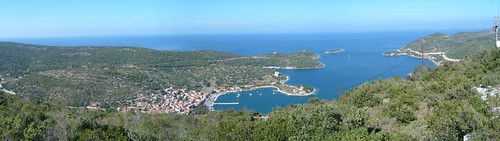
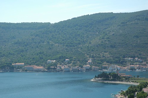
The wind is gusting, and I mess the inflation of my wing at first. The second attempt sees me in the air. I do one pass in front of the take off, but I can see I'm not gaining any height, the wind is not strong enough, so I head for the center of the bay, where I turn left to line up the church and the landing terrain. I have plenty of spare height, and the wind isn't strong at all, so I take a wide turn in front of the harbour area. That brings me to the height of the church bell tower, and I prepare the landing.
A couple of S figures bring me to the correct height and I'm lined up with the small grass patch.
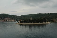
The landing is perfect, right in the middle of the field. I collapse the wing and fold it.
It was a short flight, but very pleasant, especially with the view over the water. I managed to check a few of the spots where we're going to snorkel and dive in the next few days.
Technical data: Flight duration 0:08, Take-off altitude: 336m, Maximum altitude reached: 338m, Total climb during flight: 120m, Max rate of climb: +0.6m/s, Max descent rate: -2.4m/s, Landing altitude: 0m.
It takes us a little while to find the correct path, as there are no signs, the way to the top follows gravel paths and none of them are featured on our tourist maps.
When we get to the end of the road, there is an old derelict house from which emerges a young man in his thirties. He's there to watch for fires and informs us that indeed some people do take off from the front of the house. There is a make-shift windsock. It doesn't take me long to get the glider out and the wing spread out on the rough grass.
The wind is gusting, and I mess the inflation of my wing at first. The second attempt sees me in the air. I do one pass in front of the take off, but I can see I'm not gaining any height, the wind is not strong enough, so I head for the center of the bay, where I turn left to line up the church and the landing terrain. I have plenty of spare height, and the wind isn't strong at all, so I take a wide turn in front of the harbour area. That brings me to the height of the church bell tower, and I prepare the landing.
A couple of S figures bring me to the correct height and I'm lined up with the small grass patch.
The landing is perfect, right in the middle of the field. I collapse the wing and fold it.
It was a short flight, but very pleasant, especially with the view over the water. I managed to check a few of the spots where we're going to snorkel and dive in the next few days.
Technical data: Flight duration 0:08, Take-off altitude: 336m, Maximum altitude reached: 338m, Total climb during flight: 120m, Max rate of climb: +0.6m/s, Max descent rate: -2.4m/s, Landing altitude: 0m.
posted by ParaScubaSailor at 18:57
0 comments
![]()
![]()
